Rail-Trail
| Name | High Bridge–Wilmore Rail-Trail (proposed) |
| End Points | High Bridge park and Wilmore caboose museum |
| Length | 4.5 miles (approximate) |
| Location | Jessamine County, Kentucky |
| Surface | Asphalt (proposed) |
Details
The High Bridge–Wilmore Rail-Trail is a proposed trail on the railroad bed abandoned when the (Norfolk) Southern relocated and doubled the tracks. The trail winds through beautiful forest overlooking the Kentucky River, slices through rock cuts, crosses meadows, and about midway, plunges through a tunnel. The abandoned railbed is in private ownership.
Reasons
Rail-trails provide a number of benefits to the community:
- Provides a safe and healthy area for outdoor exercise, including bicycling, rollerblading, walking, jogging, and running.
- Lets you get away to nature without going away.
- Stimulates historical interest and generates enthusiasm for historical preservation.
- Many paved rail-trails meet Americans with Disabilities Act standards for the safety and enjoyment of all.
- Links communities together.
- Draws tourists to the community.
- Brings economic benefits as trail users spend money in the community.
- Increases value of property adjoining the trail.
This makes an ideal rail-trail for a number of reasons:
- There are two ready-made trailheads: the new High Bridge park and the caboose museum in Wilmore.
- Many people in High Bridge, Ky and Wilmore, Ky are quite interested in restoring the tourism interest of High Bridge. (It was a popular destination in the 1890s).
- Wilmore prides itself in its railroad heritage and this trail would be a visible tie to the past. See the Wilmore website and the information about Scott Station.
- The existing tunnel, once cleared out, will be a great asset and interest factor.
- This would be the first rail-trail in Jessamine county, and one of the few in Kentucky.
- A portion of the trail is on secluded and unused land that provides beautiful views of the Kentucky River.
Location and Map
The simple map below shows how the abandoned line crosses State Route 29 twice between High Bridge and Wilmore.
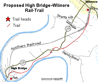
Note that this is not currently a trail. Please respect the landowners and do not trespass.
More detailed maps of the trail are available, including topographical maps and aerial photos.
Proposed Plan
Pre-construction
Many steps are necessary before trail construction can begin:
- Community interest and support needs to be built. We need a group of people dedicated to promoting and working for the rail-trail.
- Research the history of the railroad and specific abandonment date.
- Need to research land ownership related to the abandoned railroad bed. We already have a list of adjoining land owners, but need to research the land deeds and any easements.
- Develop a brochure describing the rail-trail
- Write a thorough feasibility study.
- Raise funding for rail-trail construction. Federal and state grants may be available through TEA-21 and T-21. Private and local government funding may also be necessary and/or desirable.
Construction
Actual trail construction could begin with this plan:
- Begin trail clearing and construction at High Bridge and work toward Wilmore. There's more tourist interest in the High Bridge area and access to the trail may be better.
- A Kentucky River overlook and destination along the trail could be built as part of a first phase.
- Clear debris and trash near the tunnel.
How to Help
There are many ways you can help to make this trail a reality: writing letters, making phone calls, educating others, doing research, providing financial support, and giving legal or other expert assistance. If you are interested in helping with this rail-trail, please contact Tim Powell.
Phone: (859) 858-3139
Email: railtrDonotspam@ail T worldtimzoneco· m
See Also
Photos along the proposed rail-trail:
Trail thoughts:
Rail-trail organizations: